Lake Shelbyville Links

Redirecting...

HIKING, BIKING, & WATER TRAILS

There are a multitude of trails that over a variety of hiking and biking opportunities. Precautions should be taken to stay on the marked path. Please remember to pack out what you pack in and leave the trail clean and safe for the next traveler.

LAKE SHELBYVILLE TRAIL STATUS

STATUS UPDATE: As of 29 NOVEMBER 2022

Click Trail Name for Maps!

Trail Name

Length Surface Status Trail Condition

Chief Illini Trail

11 mi. Dirt/single track

OPEN

Painted white blazes (Summer 2022) mark trail. Bridge out near Arrowhead at 2.5 mile marker. Bridge out between 10.5 might not be passable during wet conditions.

Mile markers every 0.5 miles

*Use CAUTION- Bridges impacted by high water damage

Little Illini Trail                 3.0 mi. Dirt/single track OPEN

White blazes mark trail (Summer 2022)

Bridge out near Arrowhead at 2.5 mile marker.

Coon Creek Nature Trail 0.7 mi. Dirt/single track OPEN

Good Condition. White blazes mark trail (Fall 2022)

Updates Coming soon.

Use caution on bridges

Okaw Bluff Trail                 

  Dirt/grass/road Open

Trail is poorly marked and possibly overgrown.

Camp Camfield 7.9 mi. Dirt/single track Open Excellent
General Dacey Trail 7.0 mi. Chip & seal Open

Excellent

General Dacey Trail Mtn Bike Extension

A) Boulder Loop     (2.7 mi)

B) Split Rock Loop  (1.8 mi)

C) Ag Pass            (0.9 mi)

5.4 mi. Dirt/single track Open

Blue tags mark the trail route.  Ride counter-clockwise!

Access:  Via Ag Pass Parking Lot or North Loop of GDT in Forest Park


:::More Information about Hiking and Biking Trails:::

 General Dacey Trail

Length: The General Dacey trail offers over 7 miles start to finish, however, many different trail option (loops) are available to fit your needs.

Activities: Hiking, Biking, Walking, Running, Tree ID sign, outdoor exercise equipment adjacent to trail at Dam West Overlook.

Location and Description: The General Dacey Trail is a multipurpose trail designed for walkers, runners and bicyclists. Recreational use of motorized vehicles is not permitted (excepting electric wheelchairs).This trail is a great place for the whole family to spend time together enjoying creation. Besides exercising, the trail is a great place for bird watching, geocaching and photography. The trail offers users many opportunities to pause on donated benches and contemplate stunning views of Lake Shelbyville and the area.

Parking

The General Dacey trail has serval locations where you can park and leave your car while using the trail.

1.  Lake Shelbyville, Dam West (Ninth Street Recreational Area)

Trail head parking area is located at the west end of the boat launch parking lot.  The parking area provides a trail information board.  Access to the Dam West beach, boat ramp, restrooms, and pavilion are within a short walking distance. 

2.  City of Shelbyville, Forest Park

The trail parking lot is on the north side of the park behind the scout cabin. This lot is next to a pavilion where multiple loops of the trail meet.  This parking area provides a bicycle rack, trail information board, and pavilion.   Access the the public pool, picnic tables, and playgrounds is within a short walking distance. 

3. Lake Shelbyville Visitor Center

Park at the visitor center and access the trail thatl runs directly through the visitor center parking lot.  This parking area provides bike racks, water fountains, restooms, the visitor center, and a great view of the lake!

4.  Lake Shelbyville's Dam West Overlook

Park at the overlook, located on the west side of the dam.  This parking area provides restrooms, water fountians, and views of the lake.

Dogs

Dogs are welcome on the trail. Please keep them on a leash. Please clean up after them.
 

Trail surfaces

Trail surfaces vary between crushed limestone and oil and chip. The trail is very walkable, but cyclists should take note of caution signs placed before steep grades.

 Coon Creek Nature Trail

Length: 0.7 mile

Activities: Hiking

Location and Description: Coon Creek Recreation Area provides a self-guided nature trail.  The trail head can be accessed from the north side of the boat ramp parking area.  A variety of trees, flowers, and ferns can be identified along this truly scenic trail. 

 Okaw Bluff Trail

Length: 1.2 miles

Activities: Hiking

Location and Description: This trail is located at the entrance of the Okaw Bluff Group Camp. The trail, which winds along a bluff overlooking the lake and is beside a 100 acre wetlands, includes two photography stands and a wetland/waterfowl viewing stand. The Great Blue Heron, Spotted Sandpiper, and Canada Goose are a few of the species you may encounter. Be sure to bring a camera!

 The Chief Illini Trail

Length: 11 miles

Activities: Hiking

Location and Description: The Chief Illini Trail, a registered National Recreation Trail, is a scenic journey along the edge of Lake Shelbyville. This point-to-point trail winds across rolling hills and open prairies offering close-up views of the lake. You may begin the trail at either Lone Point Recreation Area or Eagle Creek State Park.

White blazes, post markings, and mile markers make this intermediate level trail easy to follow.

 Little Chief Illini Trail

SEE CHIEF ILLINI TRAIL MAP

Length: The first 3 mile of the Chief Illini Trail

Activities: Hiking and Overnight Camping

Location and Description: This trail begins at Lone Point Recreation Area and ends near Arrowhead Campground.

An open-air Adirondack shelter with a fire ring and picnic table is available near the end of the Little Chief Illini Trail by reservation only. Length of stay is for one night only. Overnight group size is limited to 20 people.

The shelter is for use by persons who hike the trail. Campers must arrive by walking from trail entrances located at either Lone Point or Eagle Creek. To reserve the shelter, contact the Lake Shelbyville Project Office at (217)774-3951.

 State Areas
Wolf Creek State Park offers a 15 mile equestrian trail which doubles as a snowmobile trail in the winter. There are several trails in Eagle Creek State Park including a three mile cross country trail. The Shelbyville Fish and Wildlife Management Area features a four mile scenic trail that passes the Coneflower Hill Prairie in the Fishhook Area.
 Camp Camfield Trail

Length:  7 miles

Activities:  Mt Biking, hiking

Location and Description: Located near Sullivan, Illinois, Camp Camfield consists of three trails with a total of nearly 7 miles.  Camp Camfield trail is designated as a National Recreation Trail system and is maintained and operated as a mountain biking/hiking, family oriented trail.  Central Illinois Mountain Bike Association (CIMBA) maintains this trail system. 

Chief Illini Hike Patches

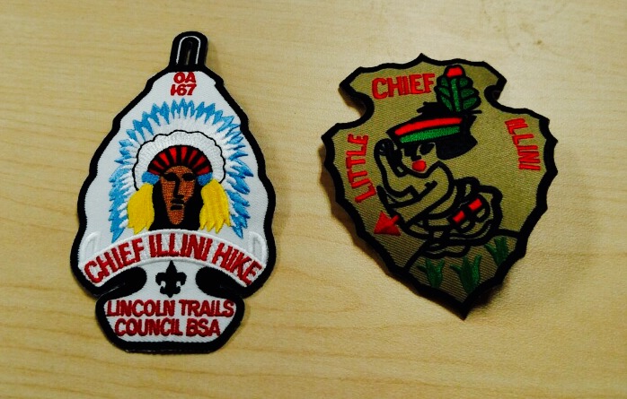
- The Chief Illini hike patch can be earned by hiking the entire 11 miles.

- The Little Chief Illini hike patch can be earned by hiking the first two miles of the trail.

***NEW***Patches are now available for a purchase of $3.00 at the Lake Shelbyville Visitor Center***


To Order, send the following information to:

Order of the Arrow

Chief Illini Trail

262 West Prairie Ave

Decatur, IL 62523

Name: _________________

Address: _________________

Phone: _________________

Unit #: _________________

Qty of Chief Illini Patches (@ $3.00 each): __________

Qty of Little Illini Patches (@ $3.00 each): ___________

+ Postage & Handling: $2.00

Total Enclosed: _________________

*prices are subject to change

*credit card is accepted by phone: 217-429-2326