Navigation
The Upper Mississippi River is best described as the stretch of the river from St. Paul, Minnesota, to the river’s confluence with the Missouri River. In the late 19th and early 20th centuries, this stretch of the Mississippi River was unreliable. During common periods of low water, the Upper Mississippi River had a shallow and swift current, rock ledges, small waterfalls, uncharted shoals and sandbars. These hazards made the river too treacherous to navigate safely.
In 1930, Congress authorized the Corps of Engineers to create and maintain a 9-foot navigation channel on the Upper Mississippi River through the construction of the slack-water navigation system. As a result, the Corps of Engineers constructed a series of locks and dams on the Upper Mississippi River. As they were completed, the pools formed upriver of each dam structure, thereby raising water levels to insure an adequate depth for the navigation channel. These structures, in essence, form an aquatic staircase some 670 miles long from St. Paul to St. Louis. As the term implies, a slack-water navigation system is comprised of a series of pools, or small lakes, created by dams constructed across the river. The pools are connected by navigation locks, which raise or lower river-bound vessels from one pool to the next. In keeping true to our responsibilities as stewards of the environment, the St. Louis District developed and implemented an Environmental Pool Management program that provides for pool “draw downs” during the summer months to promote vegetative growth and seed protection.
Navigation on the Open River
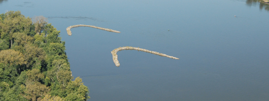
The combined waters of the Missouri and Mississippi Rivers typically assure adequate depths for navigation, except for periods of prolonged drought. Still, much effort is needed to facilitate navigation in the open river, usually in the form of maintenance dredging and regulating works. Maintenance dredging operations involve the repetitive removal of naturally deposited sediment from the navigation channel. The St. Louis District Applied River Engineering Center uses table-top “micro-models” to develop innovative solutions to various sedimentation problems. More often than not, these solutions are found in what we call “regulating works”. Regulating works are structural designs, such as chevron dikes, bendway weirs, off-bankline revetments, and notched dikes. By necessity, our river engineers seeks to implement structural designs that work in harmony with the natural laws of the river to solve problems involving sedimentation, erosion and biological diversity, all while providing a safe and dependable navigation channel.